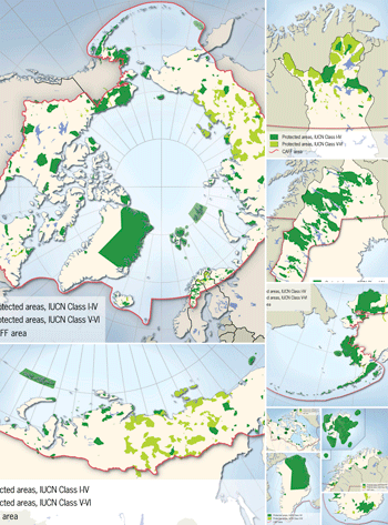
New maps over protected areas of the Arctic countries
New report from Arctic Council with maps by Nordpil
 The Arctic represents a part of the world that has, so far, seen little human impact, but is threatened by mining, oil and gas development, and climate change - to name just a few possible stresses.
The Conservation of Arctic Flora and Fauna (CAFF) is a working program of the Arctic Council, tasked with monitoring and reporting on the state and trends of ecosystems in the Arctic.
To prepare a benchmark and inventory, the Protected Areas Monitoring Scheme Background Paper was prepared, examining the current status in the Arctic countries: USA (Alaska), Canada, Greenland (Denmark), Iceland, Faeroe Islands (Denmark), Norway, Sweden, Finland and Russia.
Nordpil was commissioned to handle the spatial database that had been assembled by national partners in the CAFF network, and to prepare a set of maps for the report. The maps, prepared using ESRI ArcGIS and Adobe Illustrator, highlight the current network of national, state and territorial parks, national monuments, wildlife sanctuaries, protected bird areas (Ramsar Convention), UNESCO World Heritage sites, and other protected areas.
- The circumpolar protected areas map has been added to the portfolio collection.
- The full report: CAFF Monitoring Series Report No.5 - Circumpolar Protected Areas Monitoring Arctic Protected Areas Monitoring Scheme Background Paper is available on the Arctic Portal.
- Please refer to the Conservation of Arctic Flora and Fauna (CAFF) website for more information about Arctic Council conservation efforts.
Tags:

