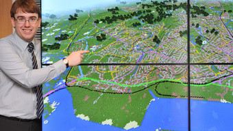
RS2818 joseph-braybrook-gb-minecraft-2-map
Ordnance Survey is Great Britain's national mapping authority, keeping 460 million geographical features updated to provide an accurate picture of the country. We collect, maintain and distribute the most accurate and up-to-date geographic information (GI) of the whole country that government, business and individuals all rely upon. From our surveyors on the ground, measuring and tracking changes; our planes that maintain our aerial photography of Great Britain; data technology specialists who build and maintain our bespoke IT systems; and product experts redefining how customers can benefit from our data, we all have one vision: to be the content provider of choice for location-based information. Our iconic maps are one of our most recognised brands, but these days digital data accounts for 93% of our business. Demand for accurate, accessible, high-quality GI has never been so high. Our database holds an entire digital map of the country with 460 million features and we work day-in, day-out to keep it up-to-date. We build products to meet our customers' needs and support our emergency services with vital road and land information, and provide data to utility companies to make sure you can get water and gas supplies to your home. From ensuring optimum routes for refuse collection to getting your shopping to your door – our work is all around you.SpecialtiesGeographical information, Web services, Cartography, Leisure maps, Geospatial data management, Surveying, Innovation, GeoVation, GIS, Paper maps, Digital maps